
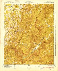
1947 Map of Cliffield Mtn.
USGS Topo · Published 1947About this map
Blue Ridge and Tennessee Ridge dominate this post-war landscape, where the rugged topography of western North Carolina transitions through numerous gaps and mountains. Small rural communities like Dana, Mill Corner, and Mount Valley are linked by a network of winding roads such as Page Rd and Sugarloaf Rd. The drainage patterns are clearly defined by the Hungry River and Green River, which carves through the distinct geological feature known as The Narrows. Family and community history is anchored in local landmarks, including Edith Grove Ch and Macedonia Ch, along with several small burial grounds such as Jones-Price Cem and Patty Cem. The Tennessee Valley Authority's 1946 field examination provides a clear look at this area's development before modern infrastructure altered the more isolated mountain corridors.
Find a feature on this map
63 named features on this map. Tap any name to fly to it.
Don’t see what you’re looking for? This feature index may not catch every label — zoom into the map to look around manually.
Map Details
Editions of this 1947 Cliffield Mtn. Map
2 editions found
Other maps of this area

1907 · Saluda
USGS Topo · 1:125,000

1935 · Batcave
USGS Topo · 1:24,000

1935 · Hendersonville
USGS Topo · 1:24,000

1935 · Fishtop
USGS Topo · 1:24,000

1935 · Zirconia
USGS Topo · 1:24,000

1936 · Fruitland
USGS Topo · 1:24,000

1942 · Fruitland
USGS Topo · 1:24,000

1946 · Zirconia
USGS Topo · 1:24,000

1946 · Bat Cave
USGS Topo · 1:24,000
1946 · Hendersonville
USGS Topo · 1:24,000