1946 Map of Hendersonville
USGS Topo · Published 1957About this map
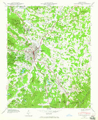
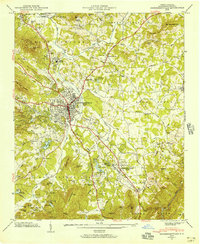
The mountain town of Hendersonville serves as the central hub for this mid-century survey, situated where the Southern railroad line intersects with the historic Dixie Highway. The landscape is a network of ridges and river valleys, characterized by a high concentration of institutional landmarks including Stanford Chapel, Moores Grove Ch, and Balfour Sch. To the south, the village of Flat Rock and the waters of Highland Lake reflect the area’s long-standing appeal as a summer retreat and residential destination.
Find a feature on this map
103 named features on this map. Tap any name to fly to it.
Don’t see what you’re looking for? This feature index may not catch every label — zoom into the map to look around manually.
Map Details
Editions of this 1946 Hendersonville Map
2 editions found
Other maps of this area

1905 · Pisgah
USGS Topo · 1:125,000

1906 · Pisgah
USGS Topo · 1:125,000

1907 · Saluda
USGS Topo · 1:125,000

1935 · Standingstone Mtn.
USGS Topo · 1:24,000

1935 · Horse Shoe
USGS Topo · 1:24,000

1935 · Batcave
USGS Topo · 1:24,000

1935 · Hendersonville
USGS Topo · 1:24,000
1935 · Fishtop
USGS Topo · 1:24,000

1935 · Zirconia
USGS Topo · 1:24,000
1936 · Skyland
USGS Topo · 1:24,000