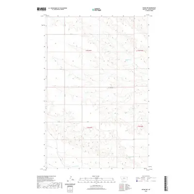
2020 Map of Intake NW
USGS Topo · Published 2020About this map
Immanuel Lutheran Cem stands as a quiet focal point in this portion of Dawson County, marking a localized site of historical and genealogical significance amidst the expansive terrain. The landscape is defined by the winding paths of Burns Cr in the north and Thirteenmile Cr toward the south, illustrating the drainage patterns that have shaped the region's topography and land use. Isolated water sources, such as 20N55E25CAA01 Spring and 19N55E25ABA01 Spring, are noted on the sheet, representing vital resources for early homesteading and livestock in this semi-arid environment. A network of secondary and local routes, including RD 527 and RD 532, sections the land along township lines, following the established Public Land Survey System that guided the area's development.
Find a feature on this map
16 named features on this map. Tap any name to fly to it.
Don’t see what you’re looking for? This feature index may not catch every label — zoom into the map to look around manually.
Map Details
Editions of this 2020 Intake NW Map
This is the sole edition of this map. No revisions or reprints were ever made.
Other maps of this area

1909 · Glendive
USGS Topo · 1:250,000

1954 · Glendive
USGS Topo · 1:250,000

1957 · Glendive
USGS Topo · 1:250,000

1958 · Glendive
USGS Topo · 1:250,000
1966 · Kolberg Ranch
USGS Topo · 1:24,000
1966 · Intake
USGS Topo · 1:24,000
1966 · Intake NW
USGS Topo · 1:24,000
1966 · Allard Ranch
USGS Topo · 1:24,000
1972 · Red Top
USGS Topo · 1:24,000
1972 · Butler Table
USGS Topo · 1:24,000