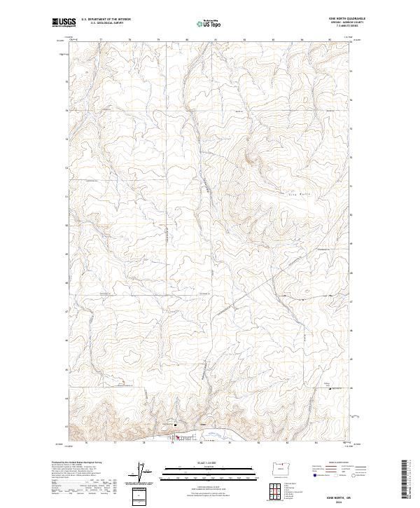
2024 Map of Ione North
USGS Topo · Published 2024About this map
Ione sits along the southern edge of this Morrow County landscape, where the seasonal flows of Willow Creek and Lorraine Creek meet the arid plateau of Eastern Oregon. The terrain is defined by a series of steep drainages, including Fourmile Canyon, Sixmile Canyon, and Rietmann Canyon, which carve through the high ground towards the valley floor. High points like Ella Butte overlook a network of rural routes that follow both section lines and natural topography, such as Ione-Boardman Rd and Johnson Grade Ln. For those tracing local genealogy or land ownership, the map provides precise locations for several burial grounds, including Lorraine Cem, Petteys Cem, and Highview Cem. The naming of local infrastructure, from Dave Rietmann Rd to Stefani Rd, reflects the established ranching and farming families who have shaped this portion of the Columbia Basin.
Find a feature on this map
31 named features on this map. Tap any name to fly to it.
Don’t see what you’re looking for? This feature index may not catch every label — zoom into the map to look around manually.
Map Details
Editions of this 2024 Ione North Map
This is the sole edition of this map. No revisions or reprints were ever made.
Other maps of this area

1906 · Blalock Island
USGS Topo · 1:125,000

1908 · Blalock Island
USGS Topo · 1:125,000

1953 · Pendleton
USGS Topo · 1:250,000

1956 · Pendleton
USGS Topo · 1:250,000

1968 · Lexington
USGS Topo · 1:24,000

1968 · Ione North
USGS Topo · 1:24,000
1968 · Utts Butte
USGS Topo · 1:24,000
1968 · Dalreed Butte
USGS Topo · 1:24,000

1968 · Ione South
USGS Topo · 1:24,000
1968 · Cecil
USGS Topo · 1:24,000