
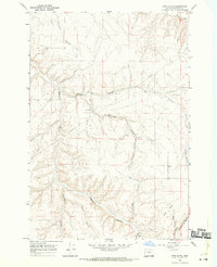
1968 Map of Ione South
USGS Topo · Published 1970About this map
Willow Creek and Rhea Creek carve through the high basalt plateaus of Morrow County, defining the agricultural and industrial corridor south of Ione. This late 1960s survey documents a landscape where traditional dryland farming meets modern energy and transport infrastructure. Along the Union Pacific tracks, Grain Elevators and a Substation mark the economic heartbeat of the valley, while the presence of Compressor Sta No 9 and a major Pipeline trace the path of utility development across the ridge tops.
Find a feature on this map
21 named features on this map. Tap any name to fly to it.
Don’t see what you’re looking for? This feature index may not catch every label — zoom into the map to look around manually.
Map Details
Editions of this 1968 Ione South Map
This is the sole edition of this map. No revisions or reprints were ever made.
Other maps of this area

1906 · Blalock Island
USGS Topo · 1:125,000

1908 · Blalock Island
USGS Topo · 1:125,000

1953 · Pendleton
USGS Topo · 1:250,000

1956 · Pendleton
USGS Topo · 1:250,000

1968 · Gooseberry
USGS Topo · 1:24,000

1968 · Lexington
USGS Topo · 1:24,000

1968 · Ione North
USGS Topo · 1:24,000

1968 · Eightmile
USGS Topo · 1:24,000
1968 · Utts Butte
USGS Topo · 1:24,000

1968 · Ruggs
USGS Topo · 1:24,000