
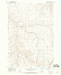
1968 Map of Gooseberry
USGS Topo · Published 1970About this map
Gooseberry and the surrounding high plateau of eastern Oregon are defined by a complex network of deep drainages in this late 1960s survey. The landscape is carved by numerous features including Youngs Canyon, Eightmile Canyon, and Gooseberry Canyon, which together create a rugged relief across the Morrow and Gilliam county lines. Human settlement is concentrated at the Gooseberry crossroads, marked by the Gooseberry Cem and a nearby Landing Strip. The map reveals a specialized agricultural and resource-based economy, indicated by the distribution of several Storage Bins scattered across the uplands and a Borrow Pit in the southern reaches. The interplay between the upland flats and the deep forks of Dry Creek illustrates the topographical challenges faced by early residents in this part of the Columbia Basin.
Find a feature on this map
17 named features on this map. Tap any name to fly to it.
Don’t see what you’re looking for? This feature index may not catch every label — zoom into the map to look around manually.
Map Details
Editions of this 1968 Gooseberry Map
This is the sole edition of this map. No revisions or reprints were ever made.
Other maps of this area

1916 · Condon
USGS Topo · 1:125,000

1953 · Pendleton
USGS Topo · 1:250,000

1953 · The Dalles
USGS Topo · 1:250,000

1956 · The Dalles
USGS Topo · 1:250,000

1956 · Pendleton
USGS Topo · 1:250,000

1957 · The Dalles
USGS Topo · 1:250,000

1968 · Eightmile
USGS Topo · 1:24,000
1968 · Utts Butte
USGS Topo · 1:24,000

1968 · Ione South
USGS Topo · 1:24,000

1969 · Buttermilk Canyon
USGS Topo · 1:24,000