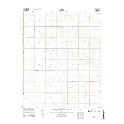
2013 Map of Ione
USGS Topo · Published 2013About this map
The high plains of eastern Union County define this landscape, where early 21st-century topography reveals a sparse network of ranch-era settlements and seasonal drainages. Small named localities like Ione, Childress, and Forester anchor the interior, connected by a grid of county roads such as CO Highway C-085 and CO Highway C-087. The terrain is etched by several important watercourses, including the westward-flowing Bob Wells Cr and the branching Minneosa Cr system. An essential water source for the region, Entrania Spring, sits near the head of Entrania Cr, illustrating the critical role of groundwater in this arid environment. The map provides a clear record of the Public Land Survey System divisions, showing the boundaries between T19N and T18N, R34E and R35E, which remain fundamental to property and genealogical research in this part of New Mexico.
Find a feature on this map
21 named features on this map. Tap any name to fly to it.
Don’t see what you’re looking for? This feature index may not catch every label — zoom into the map to look around manually.
Map Details
Editions of this 2013 Ione Map
This is the sole edition of this map. No revisions or reprints were ever made.
Other maps of this area
1954 · Tucumcari
USGS Topo · 1:250,000
1958 · Tucumcari
USGS Topo · 1:250,000
1966 · Rosebud
USGS Topo · 1:24,000
1966 · Ione
USGS Topo · 1:24,000
1966 · Hayden
USGS Topo · 1:24,000
1966 · Cherokee Valley
USGS Topo · 1:24,000
1966 · Cottonwood Springs
USGS Topo · 1:24,000
1966 · Mc Cloy Ranch
USGS Topo · 1:24,000
1971 · Kerlin Hill
USGS Topo · 1:24,000
1971 · Centerville Corner
USGS Topo · 1:24,000