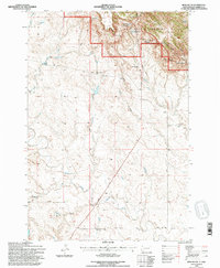
1993 Map of Irish Butte
USGS Topo · Published 1996About this map
Slim Buttes rise sharply in the northern portion of this landscape, contained within the Custer National Forest boundary. This high ground is defined by prominent formations such as Irish Butte and Adam and Eve Butte, alongside a network of seasonal water sources including Old Nail Spring and Fish Spring. The terrain transitions from these rugged heights to the lower reaches of the North Fork Moreau River valley, where the small settlement of Marty and the Guyer Sch reflect the rural infrastructure of the era. The land use outside the forest boundary is characterized by isolated operations such as Horton Ranch and Laflin Ranch, connected by unpaved routes like Hoover Road and Laflin Road. The presence of Deep Draw and Cowboy Creek highlights the drainage patterns that have historically shaped ranching life in this part of Harding County.
Find a feature on this map
25 named features on this map. Tap any name to fly to it.
Don’t see what you’re looking for? This feature index may not catch every label — zoom into the map to look around manually.
Map Details
Editions of this 1993 Irish Butte Map
This is the sole edition of this map. No revisions or reprints were ever made.
Other maps of this area

1935 · Hoover
USGS Topo · 1:125,000

1954 · Lemmon
USGS Topo · 1:250,000

1957 · Lemmon
USGS Topo · 1:250,000

1968 · Irish Butte
USGS Topo · 1:24,000

1968 · J B Hill
USGS Topo · 1:24,000

1968 · Sheep Mountain
USGS Topo · 1:24,000

1968 · Flat Top Butte
USGS Topo · 1:24,000
1977 · Granger Creek
USGS Topo · 1:24,000
1978 · Bams Butte
USGS Topo · 1:24,000
1978 · Porter Creek
USGS Topo · 1:24,000