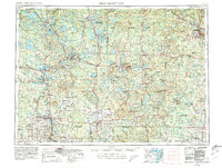
1954 Map of Iron Mountain
USGS Topo · Published 1980About this map
The Wisconsin River winds south through a dense network of glacial lakes and northern forests, anchoring timber and transport hubs like Rhinelander and Tomahawk. This 1954 survey, updated in 1980, reveals a landscape defined by the vast reaches of the Nicolet National Forest and Chequamegon National Forest, where numerous Lookout towers guarded the timberlands. To the south, the industrial centers of Wausau, Antigo, and Merrill emerge along established corridors of the Chicago and North Western Railway and the Soo Line Railroad. The map documents the northern lake country around Minocqua and the Lac du Flambeau reservation, showing the early reach of US Highway 51 and US Highway 45 into the Northern Highlands. Small settlements such as Heafford Junction, Gagen, and Starks reflect the era's rail-dependent rural geography before modern highway expansions.
Find a feature on this map
99 named features on this map. Tap any name to fly to it.
Don’t see what you’re looking for? This feature index may not catch every label — zoom into the map to look around manually.
Map Details
Editions of this 1954 Iron Mountain Map
2 editions found

Other maps of this area

1898 · Iron River
USGS Topo · 1:62,500

1899 · Sagola
USGS Topo · 1:62,500

1899 · Crystal Falls
USGS Topo · 1:62,500

1899 · Wausau
USGS Topo · 1:125,000

1902 · Wausau
USGS Topo · 1:125,000

1902 · Marathon
USGS Topo · 1:125,000

1928 · Three Lakes
USGS Topo · 1:48,000

1930 · Robbins
USGS Topo · 1:48,000

1938 · Phelps
USGS Topo · 1:48,000

1938 · Minocqua
USGS Topo · 1:48,000