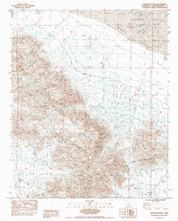
1983 Map of Iron Mountains
USGS Topo · Published 1985About this map
The Iron Mountains dominate this arid landscape in the Mojave Desert, where extreme topography meets industrial utility. This 1983 manuscript-based survey reveals the critical infrastructure of the Colorado River Aqueduct, which cuts through the southern terrain, aided by a Tunnel and protected by a Dike. To the north and east, the desert floor is defined by dry basins including Ward Valley and the expansive Danby Lake. Evidence of localized industry appears in the form of a Reservoir (For Salt Evaporator Ponds) and scattered Well (Alkali) sites. The map also records early land modifications such as a Borrow Pit and Tailings, suggesting resource extraction efforts near the intersection of the Cadiz Valley and the foothills of the Kilbeck Hills.
Find a feature on this map
17 named features on this map. Tap any name to fly to it.
Don’t see what you’re looking for? This feature index may not catch every label — zoom into the map to look around manually.
Map Details
Editions of this 1983 Iron Mountains Map
2 editions found
Other maps of this area

1942 · Amboy
USGS Topo · 1:250,000

1943 · Amboy
USGS Topo · 1:250,000

1943 · Cadiz Lake
USGS Topo · 1:62,500

1943 · Cadiz Valley
USGS Topo · 1:62,500

1943 · Iron Mountains
USGS Topo · 1:62,500

1954 · Needles
USGS Topo · 1:250,000

1956 · Needles
USGS Topo · 1:250,000

1956 · Milligan
USGS Topo · 1:62,500

1956 · Iron Mountains
USGS Topo · 1:62,500

1956 · Cadiz Lake
USGS Topo · 1:62,500