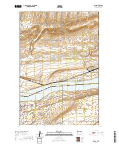
2020 Map of Irrigon
USGS Topo · Published 2020About this map
Irrigon stands as a primary settlement along the southern banks of the Columbia River, positioned where the landscape meets the expansive Lake Umatilla. This modern survey illustrates the complex water management systems vital to the region, most notably the W Extension Irrigation Canal which cuts across the southern portion of the townsite. The topography is defined by the gradual descent of the land toward the river, interrupted by drainage features such as Bing Canyon and Fourmile Canyon to the north and east. For those researching local history, the map provides precise locations for the Desert Lawn Memorial Cem and the central Po. The intricate grid of streets like NE Main Ave and E Idaho Ave reflects the town's residential development, while the Irrigon Middle Range Channel marks the navigable path through the broad river waters.
Find a feature on this map
32 named features on this map. Tap any name to fly to it.
Don’t see what you’re looking for? This feature index may not catch every label — zoom into the map to look around manually.
Map Details
Editions of this 2020 Irrigon Map
This is the sole edition of this map. No revisions or reprints were ever made.
Other maps of this area

1906 · Blalock Island
USGS Topo · 1:125,000

1908 · Blalock Island
USGS Topo · 1:125,000

1908 · Umatilla
USGS Topo · 1:125,000

1915 · Prosser
USGS Topo · 1:125,000

1917 · Pasco
USGS Topo · 1:125,000

1917 · Prosser
USGS Topo · 1:125,000

1953 · Pendleton
USGS Topo · 1:250,000

1953 · Walla Walla
USGS Topo · 1:250,000

1956 · Pendleton
USGS Topo · 1:250,000

1958 · Walla Walla
USGS Topo · 1:250,000