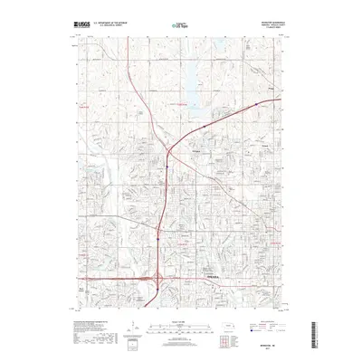
2017 Map of Irvington
USGS Topo · Published 2017About this map
Omaha expansion and the rural-urban interface of northwest Douglas County define this study, where suburban growth meets longstanding agricultural communities. The settlement of Irvington serves as a central hub, flanked by the residential developments spreading toward the historic Boys Town and smaller locales like Briggs and Debolt. Water management is a dominant landscape feature, with large-scale projects like Glenn Cunningham Lake, Standing Bear Reservoir, and the Candlewood Reservoir shaping the modern topography. Genealogists and local historians can find significant landmarks, including the Springwell Danish Cem, Mount Hope Cem, and Pleasant Hill Cem, which preserve the community's heritage amidst the evolving city. The map also documents educational and aviation assets, such as the Nebraska Methodist College and the North Omaha Airport, illustrating the complex infrastructure of a growing Midwestern metropolitan fringe.
Find a feature on this map
39 named features on this map. Tap any name to fly to it.
Don’t see what you’re looking for? This feature index may not catch every label — zoom into the map to look around manually.
Map Details
Editions of this 2017 Irvington Map
This is the sole edition of this map. No revisions or reprints were ever made.
Other maps of this area

1893 · Omaha
USGS Topo · 1:62,500

1893 · Fremont
USGS Topo · 1:125,000

1896 · Fremont
USGS Topo · 1:125,000

1954 · Omaha
USGS Topo · 1:250,000

1955 · Fremont
USGS Topo · 1:250,000

1956 · Gretna
USGS Topo · 1:24,000

1956 · Ralston
USGS Topo · 1:24,000

1956 · Irvington
USGS Topo · 1:24,000

1956 · Omaha North
USGS Topo · 1:24,000

1956 · Omaha South
USGS Topo · 1:24,000