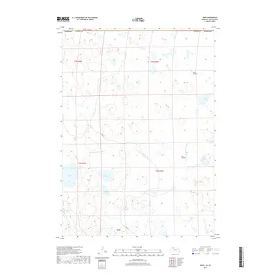
2017 Map of Irwin
USGS Topo · Published 2017About this map
The Irwin settlement area sits along the border of Nebraska and South Dakota, characterized by a complex network of wetlands and seasonal water bodies. This 2017 survey details a landscape of prairie depressions and drainage engineering, most notably the Horseshoe Drainage Ditch which cuts across the central terrain. The map reveals the hydrologic character of the Sandhills region, where large named bodies like Alkali Lake, North Twin Lake, and South Twin Lake dominate the western sections. Smaller features like Log Cabin Lake and Carpenter Lake suggest the proximity of ranching and early habitation points. To the north and east, the elevation shifts toward grassy expanses such as Scott Meadow and Slim Meadow, while the isolated Irwin RD provides the primary transit artery through this sparsely populated borderland.
Find a feature on this map
21 named features on this map. Tap any name to fly to it.
Don’t see what you’re looking for? This feature index may not catch every label — zoom into the map to look around manually.
Map Details
Editions of this 2017 Irwin Map
This is the sole edition of this map. No revisions or reprints were ever made.
Other maps of this area
1950 · Irwin
USGS Topo · 1:62,500
1951 · Irwin
USGS Topo · 1:62,500
1955 · Hot Springs
USGS Topo · 1:250,000
1955 · Alliance
USGS Topo · 1:250,000
1955 · Martin
USGS Topo · 1:250,000
1957 · Alliance
USGS Topo · 1:250,000
1957 · Valentine
USGS Topo · 1:250,000
1958 · Martin
USGS Topo · 1:250,000
1958 · Alliance
USGS Topo · 1:250,000
1959 · Valentine
USGS Topo · 1:250,000