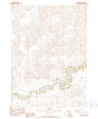
1990 Map of Irwin SE
USGS Topo · Published 1990About this map
The Niobrara River winds sharply through the southern half of this Cherry County landscape, creating a dramatic corridor of oxbows and steep-banked bends that contrast with the open Sandhills terrain to the north. At the time of this 1987 field check, the region was defined by large-scale cattle operations and isolated outposts, with several family-named landmarks including Arnot Ranch, Nielsen Ranch, Cobb Ranch, and the 71 Bar Ranch marking the spread of ranching heritage across the hills. The small settlements of Lavaca and Flats sit south of the river, anchoring a remote network of trails and unimproved roads. North of the river, Coffey Lake provides a rare water feature amidst the complex topography of the dunes, illustrating the specialized land use required to sustain livestock in this Nebraska interior during the late twentieth century.
Find a feature on this map
9 named features on this map. Tap any name to fly to it.
Don’t see what you’re looking for? This feature index may not catch every label — zoom into the map to look around manually.
Map Details
Editions of this 1990 Irwin SE Map
This is the sole edition of this map. No revisions or reprints were ever made.
Other maps of this area

1950 · Irwin
USGS Topo · 1:62,500

1951 · Irwin
USGS Topo · 1:62,500

1951 · Gypsy Valley
USGS Topo · 1:62,500

1951 · Merriman
USGS Topo · 1:62,500

1951 · Merriman 4
USGS Topo · 1:62,500

1957 · Valentine
USGS Topo · 1:250,000

1959 · Valentine
USGS Topo · 1:250,000

1985 · Cody
USGS Topo · 1:100,000
1990 · Merriman
USGS Topo · 1:24,000
1990 · Irwin
USGS Topo · 1:24,000