
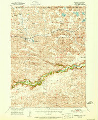
1951 Map of Merriman
USGS Topo · Published 1951About this map
Merriman serves as the primary hub of this Nebraska Sandhills region, positioned along the Chicago and North Western railroad just south of the South Dakota border. The landscape is defined by the winding Niobrara River to the south and a network of creeks including Bear Creek and Leander Creek that cut through the undulating terrain. A clear record of early 20th-century rural education is preserved here, with several district schools such as School No 74 and the noted School No 75 (Abandoned) scattered across the plains.
Find a feature on this map
27 named features on this map. Tap any name to fly to it.
Don’t see what you’re looking for? This feature index may not catch every label — zoom into the map to look around manually.
Map Details
Editions of this 1951 Merriman Map
2 editions found
Other maps of this area

1950 · Doughboy
USGS Topo · 1:62,500

1950 · Irwin
USGS Topo · 1:62,500

1951 · Irwin
USGS Topo · 1:62,500

1951 · Gypsy Valley
USGS Topo · 1:62,500

1951 · Merriman 4
USGS Topo · 1:62,500

1952 · Eli
USGS Topo · 1:62,500

1952 · Doughboy
USGS Topo · 1:62,500

1955 · Martin
USGS Topo · 1:250,000

1957 · Valentine
USGS Topo · 1:250,000

1958 · Martin
USGS Topo · 1:250,000