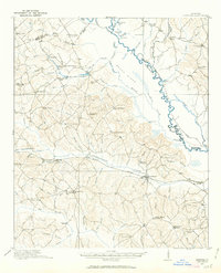
1916 Map of Irwinton
USGS Topo · Published 1963About this map
Irwinton serves as the central hub of this Wilkinson County landscape during the early twentieth century, situated amidst a dense network of family-named landmarks and rural infrastructure. The Central of Georgia railroad cuts through the heart of the territory, connecting the small rail settlements of McIntyre and Toomsboro and facilitating the movement of local resources. Further industry is evidenced by the presence of the Lumber RR near the river and Goldens Mill on Laurel Branch.
Find a feature on this map
117 named features on this map. Tap any name to fly to it.
Don’t see what you’re looking for? This feature index may not catch every label — zoom into the map to look around manually.
Map Details
Editions of this 1916 Irwinton Map
2 editions found
Other maps of this area

1912 · Milledgeville
USGS Topo · 1:62,500

1916 · Irwinton
USGS Topo · 1:62,500

1920 · Irwinton
USGS Topo · 1:62,500

1953 · Athens
USGS Topo · 1:250,000

1956 · Gordon
USGS Topo · 1:62,500

1956 · Jeffersonville
USGS Topo · 1:62,500

1957 · Macon
USGS Topo · 1:250,000

1958 · Macon
USGS Topo · 1:250,000

1958 · Athens
USGS Topo · 1:250,000

1959 · Athens
USGS Topo · 1:250,000