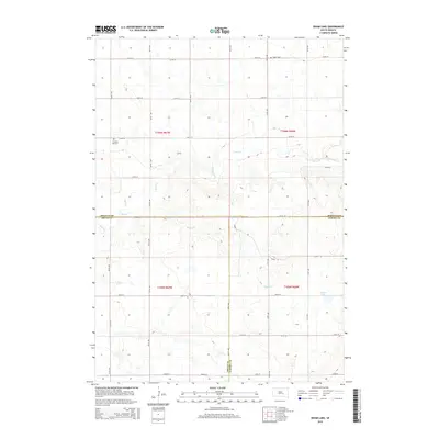
2015 Map of Isham Lake
USGS Topo · Published 2015About this map
Isham Lake sits in the southeastern corner of this South Dakota landscape, where the prairie is defined by its drainage systems and precise county boundaries. The terrain transitions across the intersection of Jerauld, Aurora, and Brule counties. This area is characterized by a network of intermittent streams, including Smith Creek and its South Fork, which carve through the undulating land. Genealogy interests are centered on the Salem Cemetery in the north and Pleasant Hill Cemetery further west, both markers of the early rural communities established here. The map reveals a strictly organized grid of rural roads, such as 238th Street and 240th Street, that facilitate movement between the drainages of Sayles Creek and the surrounding farmland during this contemporary era.
Find a feature on this map
22 named features on this map. Tap any name to fly to it.
Don’t see what you’re looking for? This feature index may not catch every label — zoom into the map to look around manually.
Map Details
Editions of this 2015 Isham Lake Map
This is the sole edition of this map. No revisions or reprints were ever made.
Other maps of this area

1941 · Kimball North
USGS Topo · 1:62,500

1942 · Crow Lake
USGS Topo · 1:62,500

1951 · Kimball North
USGS Topo · 1:62,500

1953 · Huron
USGS Topo · 1:250,000

1954 · Huron
USGS Topo · 1:250,000

1955 · Mitchell
USGS Topo · 1:250,000

1959 · Mitchell
USGS Topo · 1:250,000

1973 · Gannvalley
USGS Topo · 1:24,000
1973 · Wessington Springs SW
USGS Topo · 1:24,000
1973 · Gannvalley SE
USGS Topo · 1:24,000