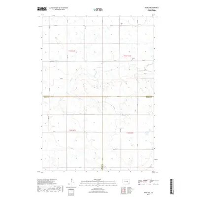
2017 Map of Isham Lake
USGS Topo · Published 2017About this map
The rolling plains at the intersection of Jerauld, Brule, and Aurora counties are defined by a network of seasonal drainages and local heritage sites. At the heart of this rural landscape, Smith Creek and its tributary S Fork Smith Cr carve shallow valleys through the prairie. The map provides a detailed look at the scattered pioneer legacies of the region, anchored by the Salem Cem in the north and the Crow Lake Catholic Cem further south. Near the eastern boundary, Isham Lake sits as a quiet landmark amidst the grid of country roads like 238th St and 371st Ave. This area remains largely defined by the original Public Land Survey System sections, where the Pleasant Hill Cem marks a point of historical continuity for local families in this agricultural corner of South Dakota.
Find a feature on this map
24 named features on this map. Tap any name to fly to it.
Don’t see what you’re looking for? This feature index may not catch every label — zoom into the map to look around manually.
Map Details
Editions of this 2017 Isham Lake Map
This is the sole edition of this map. No revisions or reprints were ever made.
Other maps of this area

1941 · Kimball North
USGS Topo · 1:62,500

1942 · Crow Lake
USGS Topo · 1:62,500

1951 · Kimball North
USGS Topo · 1:62,500

1953 · Huron
USGS Topo · 1:250,000

1954 · Huron
USGS Topo · 1:250,000

1955 · Mitchell
USGS Topo · 1:250,000

1959 · Mitchell
USGS Topo · 1:250,000

1973 · Gannvalley
USGS Topo · 1:24,000
1973 · Wessington Springs SW
USGS Topo · 1:24,000
1973 · Gannvalley SE
USGS Topo · 1:24,000