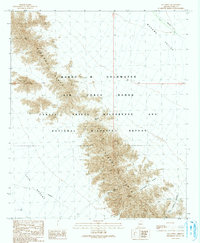
1990 Map of Isla Pinta
USGS Topo · Published 1991About this map
The Sierra Pinta range dominates this landscape, carving a sharp spine between the Mohawk Valley to the northeast and the Tule Desert to the southwest. This territory is strictly managed, falling within the Barry M Goldwater Air Force Range and the Cabeza Prieta Wilderness and National Wildlife Refuge. The map provides a detailed look at the arid hydrology of the region, featuring crucial desert water catchments like Heart Tank and Eagle Tank. Navigational markers through the high ground include Sunday Pass, while the eastern slopes are dissected by numerous drainage systems such as Hummingbird Canyon, Chia Canyon, and Eagle Canyon. The presence of large restricted zones underscores the area's dual role as a sensitive ecological sanctuary and a strategic military training ground during the late twentieth century.
Find a feature on this map
14 named features on this map. Tap any name to fly to it.
Don’t see what you’re looking for? This feature index may not catch every label — zoom into the map to look around manually.
Map Details
Editions of this 1990 Isla Pinta Map
This is the sole edition of this map. No revisions or reprints were ever made.
Other maps of this area

1953 · Ajo
USGS Topo · 1:250,000

1957 · Ajo
USGS Topo · 1:250,000

1958 · Ajo
USGS Topo · 1:250,000

1962 · Ajo
USGS Topo · 1:250,000

1963 · Ajo
USGS Topo · 1:250,000

1965 · O'Neill Hills
USGS Topo · 1:62,500

1965 · Granite Mountains
USGS Topo · 1:62,500

1965 · Isla Pinta
USGS Topo · 1:62,500

1965 · Sierra Arida
USGS Topo · 1:62,500

1967 · Ajo
USGS Topo · 1:250,000