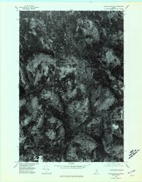
1975 Map of Island Falls NE
USGS Topo · Published 1980About this map
Knowles Corner serves as the primary human landmark in this section of Aroostook County, situated at a crossroad amidst the dense timberlands and waterways of Northern Maine. Captured during an October 1975 aerial survey, the orthophotograph reveals a landscape defined by industrial forestry and the natural drainage patterns of the Mattawamkeag River. The high-contrast imagery highlights the stark transition between thick evergreen canopies and cleared tracts near Dudley Brook. To the west, the dark expanse of Rockabema Lake sits at the base of the prominent Shoaler Mtn, illustrating the topographical variation of the Maine interior before the heavy snows of winter set in. This survey is particularly useful for observing the specific road network and land-use boundaries around the small settlement of Knowles Corner during the mid-1970s.
Find a feature on this map
5 named features on this map. Tap any name to fly to it.
Don’t see what you’re looking for? This feature index may not catch every label — zoom into the map to look around manually.
Map Details
Editions of this 1975 Island Falls NE Map
2 editions found
Other maps of this area

1935 · Howe Brook
USGS Topo · 1:48,000

1937 · Smyrna Mills
USGS Topo · 1:62,500

1939 · Howe Brook
USGS Topo · 1:62,500

1940 · Island Falls
USGS Topo · 1:62,500

1940 · Oxbow
USGS Topo · 1:62,500

1942 · Island Falls
USGS Topo · 1:62,500

1942 · Oxbow
USGS Topo · 1:62,500

1954 · Howe Brook
USGS Topo · 1:62,500

1954 · Presque Isle
USGS Topo · 1:250,000

1955 · Smyrna Mills
USGS Topo · 1:62,500
Featured Places
- T8 R5 WELS, ME
- Webbertown Township, ME
- T7 R5 WELS, ME
- Pride, Saint Croix Township
- Saint Croix Township, ME