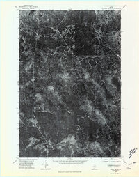
1975 Map of Oxbow SE
USGS Topo · Published 1981About this map
Mc Nally Ridge dominates this 1975 aerial perspective of the Maine timberlands, where the landscape is defined by the dense forest cover and drainage patterns typical of northern Aroostook County. This orthophotoquad reveals the intricate textures of the canopy and the clear-cut paths of logging roads that navigate the varying elevations. The hydrology of the region is traced by Roach Brook and Tracy Brook, which cut through the wooded terrain. Unlike a traditional topographic map, this photographic survey provides a literal view of the vegetation and land use during the mid-1970s, offering researchers a raw look at the industrial and natural state of the North Maine Woods before modern reforestation and development cycles changed the visible footprint of the timber industry.
Find a feature on this map
3 named features on this map. Tap any name to fly to it.
Don’t see what you’re looking for? This feature index may not catch every label — zoom into the map to look around manually.
Map Details
Editions of this 1975 Oxbow SE Map
2 editions found
Other maps of this area

1935 · Howe Brook
USGS Topo · 1:48,000

1937 · Smyrna Mills
USGS Topo · 1:62,500

1939 · Howe Brook
USGS Topo · 1:62,500

1940 · Island Falls
USGS Topo · 1:62,500

1940 · Oxbow
USGS Topo · 1:62,500

1942 · Island Falls
USGS Topo · 1:62,500

1942 · Oxbow
USGS Topo · 1:62,500

1954 · Howe Brook
USGS Topo · 1:62,500

1954 · Presque Isle
USGS Topo · 1:250,000

1955 · Smyrna Mills
USGS Topo · 1:62,500
Featured Places
- T8 R5 WELS, ME
- Webbertown Township, ME
- T7 R5 WELS, ME
- Pride, Saint Croix Township
- Saint Croix Township, ME