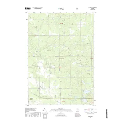
2019 Map of Island Lake
USGS Topo · Published 2019About this map
Huron National Forest dominates this section of Oscoda County, where a dense network of recreational trails and forest roads crisscross the sandy pine barrens and hardwoods. This 2019 survey captures the modern geography of an area defined by its water, from the small Gopher Lake and South Helmer Lake to the more prominent Island Lake and Loon Lake near the Ogemaw County line. The land rises to Timberline Mtn in the east, while the northern portion is drained by Lost Cr and the E Br Big Cr. Cultural and genealogical markers are preserved in the landscape, such as the Union Corners Cem and the specific marker for Hughes Grave located south of Hughes Lake. The map details an extensive trail system, including the long-distance MI Shore to Shore Horse&Hike trail and various motorized routes like the Meadows-MCCCT.
Find a feature on this map
75 named features on this map. Tap any name to fly to it.
Don’t see what you’re looking for? This feature index may not catch every label — zoom into the map to look around manually.
Map Details
Editions of this 2019 Island Lake Map
This is the sole edition of this map. No revisions or reprints were ever made.
Other maps of this area

1954 · Traverse City
USGS Topo · 1:250,000

1958 · Traverse City
USGS Topo · 1:250,000

1963 · Luzerne
USGS Topo · 1:24,000

1963 · Red Oak
USGS Topo · 1:24,000

1965 · Damon
USGS Topo · 1:24,000

1965 · St. Helen NE
USGS Topo · 1:24,000

1965 · Rose City
USGS Topo · 1:24,000

1972 · Mio
USGS Topo · 1:24,000

1972 · Mack Lake
USGS Topo · 1:24,000
1972 · Island Lake
USGS Topo · 1:24,000