
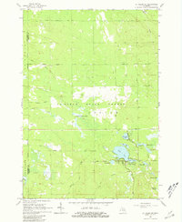
1965 Map of St. Helen NE
USGS Topo · Published 1966About this map
The Ogemaw State Forest dominates this mid-1960s landscape, illustrating a region defined by managed timberlands and glacial water features. The boundary between Roscommon and Ogemaw Counties runs north-to-south through the western portion, intersecting with an Old Railroad Grade and an Oil Well that hint at the area's extractive industrial history. Transportation is characterized by primitive routes like the Ranch Trail and Turney Road, while more localized infrastructure is visible near the Claypit and the Fisk Cem.
Find a feature on this map
31 named features on this map. Tap any name to fly to it.
Don’t see what you’re looking for? This feature index may not catch every label — zoom into the map to look around manually.
Map Details
Editions of this 1965 St. Helen NE Map
2 editions found
Other maps of this area

1954 · Traverse City
USGS Topo · 1:250,000

1958 · Traverse City
USGS Topo · 1:250,000

1963 · Luzerne
USGS Topo · 1:24,000

1963 · Eldorado
USGS Topo · 1:24,000

1965 · Damon
USGS Topo · 1:24,000

1965 · St. Helen NW
USGS Topo · 1:24,000

1965 · West Branch
USGS Topo · 1:24,000

1965 · St. Helen
USGS Topo · 1:24,000

1965 · Ogemaw Springs
USGS Topo · 1:24,000
1972 · Island Lake
USGS Topo · 1:24,000