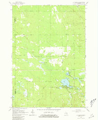
1965 Map of St. Helen NE
USGS Topo · Published 1981About this map
The Au Sable State Forest dominates this mid-1960s landscape, illustrating a region defined by reforestation and early ranching infrastructure. Long-distance tracks like the Gilford Ranch Trail and Turney Ranch Trail crisscross the northern sections, while the presence of an Old Railroad Grade and a localized claypit point to earlier eras of resource extraction and transport.
Find a feature on this map
32 named features on this map. Tap any name to fly to it.
Don’t see what you’re looking for? This feature index may not catch every label — zoom into the map to look around manually.
Map Details
Editions of this 1965 St. Helen NE Map
2 editions found
Other maps of this area

1954 · Traverse City
USGS Topo · 1:250,000

1958 · Traverse City
USGS Topo · 1:250,000

1963 · Luzerne
USGS Topo · 1:24,000

1963 · Eldorado
USGS Topo · 1:24,000

1965 · Damon
USGS Topo · 1:24,000

1965 · St. Helen NW
USGS Topo · 1:24,000

1965 · St. Helen NE
USGS Topo · 1:24,000

1965 · West Branch
USGS Topo · 1:24,000

1965 · St. Helen
USGS Topo · 1:24,000

1965 · Ogemaw Springs
USGS Topo · 1:24,000