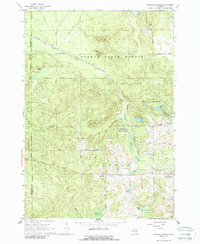
1965 Map of Ogemaw Springs
USGS Topo · Published 1988About this map
Ogemaw State Forest dominates the landscape of this mid-1960s survey, illustrating a region defined by its conversion from early industrial corridors to recreational and conservation land. The route of the New York Central railroad cuts across the northern terrain, while an Old Railroad Grade further south marks the footprint of earlier logging or transport networks. This map is particularly valuable for local history, showing the distribution of rural civic life through landmarks like Townhall, the Pleasant Hill Sch, and Harcourt Sch.
Find a feature on this map
37 named features on this map. Tap any name to fly to it.
Don’t see what you’re looking for? This feature index may not catch every label — zoom into the map to look around manually.
Map Details
Editions of this 1965 Ogemaw Springs Map
2 editions found
Other maps of this area

1954 · Traverse City
USGS Topo · 1:250,000

1958 · Traverse City
USGS Topo · 1:250,000

1965 · Damon
USGS Topo · 1:24,000

1965 · St. Helen NW
USGS Topo · 1:24,000

1965 · St. Helen NE
USGS Topo · 1:24,000

1965 · West Branch
USGS Topo · 1:24,000

1965 · St. Helen
USGS Topo · 1:24,000

1965 · Ogemaw Springs
USGS Topo · 1:24,000

1968 · Sterling NW
USGS Topo · 1:24,000

1969 · Edwards
USGS Topo · 1:24,000