
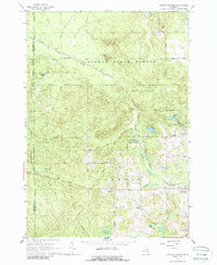
1965 Map of Ogemaw Springs
USGS Topo · Published 1966About this map
The Foster Ogemaw State Forest covers much of this landscape, where the New York Central railroad cuts a diagonal path through dense woodlands and wetlands. This mid-1960s environment is defined by its transition from high ground like Preachers Hill to the low reaches of Harcourt Swamp and Ogemaw Swamp. Traces of earlier transportation and settlement patterns are evident in the numerous Old Grade Railroad segments and the presence of the Beaver Lake Cem tucked away near Beaver Lake.
Find a feature on this map
39 named features on this map. Tap any name to fly to it.
Don’t see what you’re looking for? This feature index may not catch every label — zoom into the map to look around manually.
Map Details
Editions of this 1965 Ogemaw Springs Map
2 editions found
Other maps of this area

1954 · Traverse City
USGS Topo · 1:250,000

1958 · Traverse City
USGS Topo · 1:250,000

1965 · Damon
USGS Topo · 1:24,000

1965 · St. Helen NW
USGS Topo · 1:24,000

1965 · St. Helen NE
USGS Topo · 1:24,000

1965 · West Branch
USGS Topo · 1:24,000

1965 · St. Helen
USGS Topo · 1:24,000

1968 · Sterling NW
USGS Topo · 1:24,000

1969 · Edwards
USGS Topo · 1:24,000

1969 · Butman
USGS Topo · 1:24,000