1999 Map of Island Of Tinian
USGS Topo · Published 2001About this map
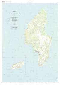
The North Field Military Reservation dominates the northern reaches of the island, a landscape defined by its wartime aviation legacy and expansive grid of runways. This 1999 documentation reflects the enduring strategic importance of the island, showing the development of San Jose and the coastal activity surrounding Tinian Harbor. The island's geography is characterized by high coastal bluffs and steep drops, most notably at Suicide Cliff on the southern tip, while the interior is marked by various agricultural and regional zones such as Kahet and Masalok. Local history is anchored by specific landmarks including a Cemetery and the Leprosarium near the western shore. South of the main island, the smaller islet of Aguijan appears as a distinct topographic landmass, separated by the Tinian Channel. The map provides a look at the transition of the island from a purely military outpost to an integrated landscape containing the West Tinian Airport and the primary roadway of Broadway.
Find a feature on this map
64 named features on this map. Tap any name to fly to it.
Don’t see what you’re looking for? This feature index may not catch every label — zoom into the map to look around manually.
Map Details
Editions of this 1999 Island Of Tinian Map
This is the sole edition of this map. No revisions or reprints were ever made.
Other maps of this area
Featured Places
- San Jose, San Jose (Tinian)
- San Jose (Tinian), Tinian Municipality
- Northern Mariana Islands
- Carolina's Heights, Tinian Municipality
- Marpo Heights, Tinian Municipality