Loading...
Loading map...1983 Map of Island Of Saipan
USGS Topo · Published 1983About this map
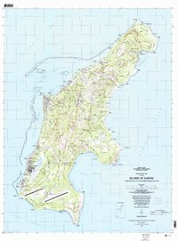
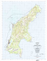
Garapan and Chalan Kanoa serve as the primary hubs of development on the western coast of Saipan in this early 1980s survey. The map details the transition from the bustling Lagunan Tanapag shoreline to the high elevations of the interior, such as As Matuis and Talofofo. Significant infrastructure is visible across the southern plains, most notably the Saipan International Airport and the nearby U.S. Coast Guard Reservation.
Find a feature on this map
49 named features on this map. Tap any name to fly to it.
Don’t see what you’re looking for? This feature index may not catch every label — zoom into the map to look around manually.
Map Details
Date Portrayed1983
Date Published1983
PublisherU.S. Geological Survey
Map TypeTopographic
Scale1:25,000
Physical Dimensions30 x 40.6 inches
Editions of this 1983 Island Of Saipan Map
2 editions found
Other maps of this area
Featured Places
- Garapan, Saipan Municipality
- Chalan Piao, Saipan Municipality
- Susupe, Saipan Municipality
- San Jose (Saipan), Saipan Municipality
- Puerto Rico, Saipan Municipality
Source Details
SourceU.S. Geological Survey
CopyrightPublic Domain