1999 Map of Island Of Saipan
USGS Topo · Published 2001About this map
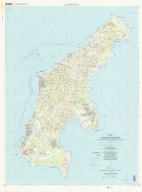
The western coast of Saipan at the turn of the millennium is anchored by the dense corridor of Garapan, Susupe, and Chalan Kanoa, stretching along the Lagunan Garapan. This survey reflects a mature island infrastructure, prominently featuring the Saipan International Airport at the southern end and the administrative center at Capitol Hill. The geography is defined by a mix of residential expansion in villages like San Vicente and Kagman I, alongside large-scale recreational development at the Laolao Golf Course and Marpi Golf Course.
Find a feature on this map
80 named features on this map. Tap any name to fly to it.
Don’t see what you’re looking for? This feature index may not catch every label — zoom into the map to look around manually.
Map Details
Editions of this 1999 Island Of Saipan Map
This is the sole edition of this map. No revisions or reprints were ever made.
Other maps of this area
Featured Places
- Garapan, Saipan Municipality
- Chalan Piao, Saipan Municipality
- Susupe, Saipan Municipality
- San Jose (Saipan), Saipan Municipality
- Puerto Rico, Saipan Municipality