1983 Map of Island Of Tinian
USGS Topo · Published 1983About this map
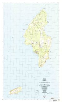
San Jose serves as the primary hub of activity on this island landscape, situated just above Tinian Harbor. The map reveals a land defined by its military history and ancient heritage, where the massive grids of North Field and West Field dominate the northern and central plateaus. These airfield complexes are interspersed with archaeological and cultural landmarks, such as the House of Taga and various Latte Stone sites, reflecting a deep layering of Chamorro tradition and 20th-century conflict.
Find a feature on this map
71 named features on this map. Tap any name to fly to it.
Don’t see what you’re looking for? This feature index may not catch every label — zoom into the map to look around manually.
Map Details
Editions of this 1983 Island Of Tinian Map
This is the sole edition of this map. No revisions or reprints were ever made.
Other maps of this area
Featured Places
- San Jose, San Jose (Tinian)
- San Jose (Tinian), Tinian Municipality
- Northern Mariana Islands
- Carolina's Heights, Tinian Municipality
- Marpo Heights, Tinian Municipality