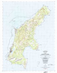
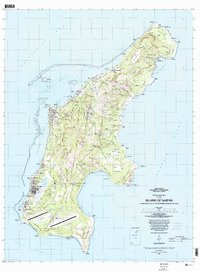
1983 Map of Island Of Saipan
USGS Topo · Published 1983About this map
The Island of Saipan is mapped here in comprehensive detail, reflecting the landscape of the Northern Mariana Islands roughly four decades after the conflict of the mid-twentieth century. Coastal settlements including Garapan, Chalan Kanoa, and San Jose line the western shore along Lagunan Garapan, while the southern end is anchored by the Saipan International Airport. The topography is dominated by the central ridge including Achugao and Kalabera, falling away to the dramatic Banzai Cliff and Puntan Sabaneta in the north. This survey documents the intersection of modern infrastructure and memory, noting a Historical Marker and Historical Landmark alongside an Abandoned Airfield and Abandoned Mine. Marine features are equally well-represented, from the Saipan Channel to the numerous coves such as Unai Talofofo and the vast Bahia Laolao.
Find a feature on this map
151 named features on this map. Tap any name to fly to it.
Don’t see what you’re looking for? This feature index may not catch every label — zoom into the map to look around manually.
Map Details
Editions of this 1983 Island Of Saipan Map
2 editions found
Other maps of this area
Featured Places
- Garapan, Saipan Municipality
- Chalan Piao, Saipan Municipality
- Susupe, Saipan Municipality
- San Jose (Saipan), Saipan Municipality
- Puerto Rico, Saipan Municipality