
1924 Map of Island Pond
USGS Topo · Published 1924About this map
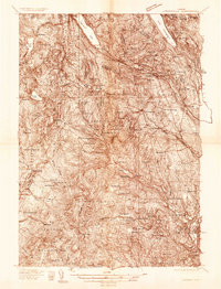
Island Pond serves as the focal point of this 1924 survey of the Northeast Kingdom, where the Grand Trunk Railway follows the valley south of the Clyde River. The map captures a transition period in northern Vermont, showing a landscape defined by isolated hill schools such as the Iron Bridge School, Bemis School, and Nickerson School. The International Boundary between the United States and Canada is clearly delineated at the northern edge, marked by the border settlement of Norton Mills.
Find a feature on this map
126 named features on this map. Tap any name to fly to it.
Don’t see what you’re looking for? This feature index may not catch every label — zoom into the map to look around manually.
Map Details
Editions of this 1924 Island Pond Map
This is the sole edition of this map. No revisions or reprints were ever made.
Other maps of this area

1919 · Lake Memphremagog
USGS Topo · 1:62,500

1920 · Derby
USGS Topo · 1:62,500

1920 · Guildhall
USGS Topo · 1:62,500

1923 · Lake Memphremagog
USGS Topo · 1:48,000

1925 · Memphremagog
USGS Topo · 1:62,500

1926 · Island Pond
USGS Topo · 1:62,500

1929 · Averill
USGS Topo · 1:62,500

1931 · Guildhall
USGS Topo · 1:48,000

1933 · Guildhall
USGS Topo · 1:48,000
1935 · Lyndonville
USGS Topo · 1:48,000