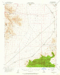
1956 Map of Ivanpah
USGS Topo · Published 1963About this map
Mining operations and remote desert outposts define this 1956 mid-century survey of the high Mojave landscape. The Union Pacific railroad corridor serves as the industrial spine of the region, connecting small stations like Nipton, Moore, and Brant. Further east, the historical weight of the Von Schmidt Line (Approx) (1873) marks the enduring boundary between California and Nevada.
Find a feature on this map
48 named features on this map. Tap any name to fly to it.
Don’t see what you’re looking for? This feature index may not catch every label — zoom into the map to look around manually.
Map Details
Editions of this 1956 Ivanpah Map
3 editions found

Other maps of this area

1910 · Ivanpah
USGS Topo · 1:250,000

1912 · Ivanpah
USGS Topo · 1:250,000

1942 · Ivanpah
USGS Topo · 1:250,000

1947 · Kingman
USGS Topo · 1:250,000

1948 · Kingman
USGS Topo · 1:250,000

1954 · Kingman
USGS Topo · 1:250,000

1955 · Kingman
USGS Topo · 1:250,000

1955 · Mescal Range
USGS Topo · 1:62,500

1955 · Roach Lake
USGS Topo · 1:62,500

1955 · Mid Hills
USGS Topo · 1:62,500