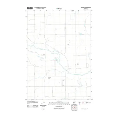
2010 Map of Iverson Lake
USGS Topo · Published 2010About this map
The Minnesota River winds through this rural landscape in Redwood County, defining the agricultural and geological character of the region. This 2010 survey reveals a land shaped by its waterways and small, scattered settlements such as Middag Knutea. The topography is marked by several significant drainage features, including the meandering Boiling Spring Creek and Echo Creek, which feed into the primary river valley. For genealogists and local historians, the map is a primary resource for locating several isolated burial grounds. These include the Swedes Forest Township Cemetery, Rock Dell Cemetery, and the Koldorn Family Cemetery, which speak to the early family-based settlement patterns of the township. In addition to the river, local water bodies like Iverson Lake, Long Lake, and Nordeen Slough represent the low-lying wetlands and glacial remnants found between the strictly gridded township roads like County Hwy-7 and County Hwy-12.
Find a feature on this map
44 named features on this map. Tap any name to fly to it.
Don’t see what you’re looking for? This feature index may not catch every label — zoom into the map to look around manually.
Map Details
Editions of this 2010 Iverson Lake Map
This is the sole edition of this map. No revisions or reprints were ever made.
Other maps of this area

1952 · Redwood Falls
USGS Topo · 1:62,500

1953 · New Ulm
USGS Topo · 1:250,000

1957 · New Ulm
USGS Topo · 1:250,000

1958 · New Ulm
USGS Topo · 1:250,000

1965 · Echo
USGS Topo · 1:24,000

1965 · Lone Tree Lake
USGS Topo · 1:24,000

1965 · Belview
USGS Topo · 1:24,000

1965 · Iverson Lake
USGS Topo · 1:24,000

1965 · Sacred Heart
USGS Topo · 1:24,000

1965 · Renville
USGS Topo · 1:24,000