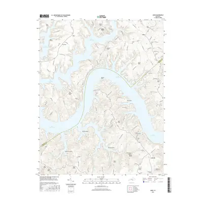
2016 Map of Jabez
USGS Topo · Published 2016About this map
Lake Cumberland dominates this landscape, its deep fingers reaching into the many hollows and ridges of the Kentucky shoreline. The intricate coastline is defined by prominent points like Ramsey Point and elevated features such as Cave Springs Ridge and Denny Ridge. This 2016 survey illustrates the modern configuration of the lake and its surrounding communities, where long-standing family history is preserved in numerous burial sites like Norfleet Cem, Coffey Cem, and Hatfield Cem. Small settlements and residential clusters such as Ono, Jabez, and Eadsville are connected by a network of winding roads like W Old Jamestown Rd and Jabez Rd. The map reveals how the modern landscape is shaped by the rising waters of the lake, which has submerged old stream valleys like Lick Cr and Puckett Br, turning former hillsides into a series of isolated ridges and quiet coves.
Find a feature on this map
114 named features on this map. Tap any name to fly to it.
Don’t see what you’re looking for? This feature index may not catch every label — zoom into the map to look around manually.
Map Details
Editions of this 2016 Jabez Map
This is the sole edition of this map. No revisions or reprints were ever made.
Other maps of this area

1911 · Monticello
USGS Topo · 1:62,500

1914 · Monticello
USGS Topo · 1:62,500

1953 · Parnell
USGS Topo · 1:24,000

1953 · Monticello
USGS Topo · 1:24,000

1953 · Mill Springs
USGS Topo · 1:24,000

1953 · Jamestown
USGS Topo · 1:24,000

1954 · Jabez
USGS Topo · 1:24,000

1954 · Cumberland City
USGS Topo · 1:24,000

1954 · Russell Springs
USGS Topo · 1:24,000

1954 · Eli
USGS Topo · 1:24,000