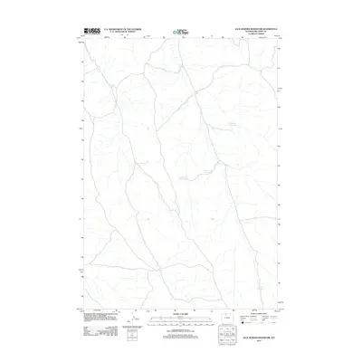
2012 Map of Jack Horner Reservoir
USGS Topo · Published 2012About this map
Jack Horner Reservoir and several neighboring catchments define the water management landscape of this section of Big Horn County. In a region shaped by aridity, these named reservoirs illustrate the engineering efforts required to support ranching and local land use. The map reveals a network of intermittent drainage channels that feed into Tommy Tucker Reservoir and the two distinct basins of North Snyder Reservoir and Snyder Reservoir. These features are connected by a sparse grid of roads and tracks that navigate the varied elevations of the Wyoming basin, providing essential infrastructure for the isolated holdings in the area. This 2012 survey provides a clear view of the rural hydraulic systems and boundary lines as they existed in the early 21st century.
Find a feature on this map
4 named features on this map. Tap any name to fly to it.
Don’t see what you’re looking for? This feature index may not catch every label — zoom into the map to look around manually.
Map Details
Editions of this 2012 Jack Horner Reservoir Map
This is the sole edition of this map. No revisions or reprints were ever made.
Other maps of this area

1955 · Cody
USGS Topo · 1:250,000

1958 · Cody
USGS Topo · 1:250,000

1962 · Cody
USGS Topo · 1:250,000

1964 · Lovell Lakes
USGS Topo · 1:24,000

1966 · Gilmore Hill NE
USGS Topo · 1:24,000

1966 · North Emblem Reservoir
USGS Topo · 1:24,000

1966 · Gilmore Hill SE
USGS Topo · 1:24,000

1966 · Jack Horner Reservoir
USGS Topo · 1:24,000

1966 · Emblem SE
USGS Topo · 1:24,000
1966 · Lovell
USGS Topo · 1:24,000