
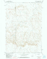
1966 Map of Gilmore Hill SE
USGS Topo · Published 1969About this map
The Jim Bridger Trail winds through the heart of this landscape, marking a historical corridor across the high basins of the Bighorn Basin during the mid-1960s. The terrain is defined by the complex drainage systems of Coon Creek and its southern tributary, the West Fork South Coon Creek, which carve through the arid topography near the Park Co Big Horn Co line. Water management in this dry environment is evidenced by the presence of Johnson Reservoir No 2 and scattered Well markers. The northern reaches are characterized by the flow of Whistle Creek, while the intricate contour lines illustrate the deeply dissected ridges and breaks typical of this Wyoming region before modern intensification. This survey captures a moment of quiet isolation, where the legacy of early western passage via the Bridger Trail remained a prominent physical feature on the land.
Find a feature on this map
8 named features on this map. Tap any name to fly to it.
Don’t see what you’re looking for? This feature index may not catch every label — zoom into the map to look around manually.
Map Details
Editions of this 1966 Gilmore Hill SE Map
2 editions found
Other maps of this area

1951 · Burlington
USGS Topo · 1:24,000

1951 · Y U Bench NW
USGS Topo · 1:24,000

1951 · Y U Bench NE
USGS Topo · 1:24,000

1955 · Cody
USGS Topo · 1:250,000

1958 · Cody
USGS Topo · 1:250,000

1962 · Cody
USGS Topo · 1:250,000

1966 · Gilmore Hill NE
USGS Topo · 1:24,000

1966 · Jack Horner Reservoir
USGS Topo · 1:24,000

1966 · Gilmore Hill NW
USGS Topo · 1:24,000

1966 · Gilmore Hill
USGS Topo · 1:24,000