
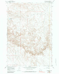
1966 Map of Gilmore Hill
USGS Topo · Published 1970About this map
Whistle Creek and its many tributaries, including the North Branch West Branch Whistle Creek, define this portion of the Bighorn Basin. In the mid-1960s, the landscape was a mix of drainage systems and early water management infrastructure. The Wiley Canal cuts across the southern edge of the map, illustrating the human effort to divert water for agricultural use in this arid region of Park County.
Find a feature on this map
13 named features on this map. Tap any name to fly to it.
Don’t see what you’re looking for? This feature index may not catch every label — zoom into the map to look around manually.
Map Details
Editions of this 1966 Gilmore Hill Map
2 editions found
Other maps of this area

1911 · Oregon Basin
USGS Topo · 1:62,500

1913 · Oregon Basin
USGS Topo · 1:62,500

1951 · Y U Bench NW
USGS Topo · 1:24,000

1951 · Y U Bench NE
USGS Topo · 1:24,000

1955 · Cody
USGS Topo · 1:250,000

1958 · Cody
USGS Topo · 1:250,000

1962 · Cody
USGS Topo · 1:250,000

1966 · Gilmore Hill NE
USGS Topo · 1:24,000

1966 · Gilmore Hill SE
USGS Topo · 1:24,000

1966 · Stone Barn Camp
USGS Topo · 1:24,000