
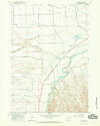
1966 Map of Stone Barn Camp
USGS Topo · Published 1969About this map
Mc Cullough Peaks dominate this mid-1960s landscape, where intricate drainage patterns and water management define the high plains of Wyoming. This survey reveals a remote area focused on water conservation and cattle ranching, evidenced by several uniquely named water storage sites like Back Scratcher Reservoir and Crazy Quilt Reservoir. These small-scale impoundments, along with Mc Lean-Gulch Reservoir, provided essential hydration in an arid environment cut by Whistle Creek and Deer Creek.
Find a feature on this map
18 named features on this map. Tap any name to fly to it.
Don’t see what you’re looking for? This feature index may not catch every label — zoom into the map to look around manually.
Map Details
Editions of this 1966 Stone Barn Camp Map
This is the sole edition of this map. No revisions or reprints were ever made.
Other maps of this area

1911 · Oregon Basin
USGS Topo · 1:62,500

1913 · Oregon Basin
USGS Topo · 1:62,500

1951 · Y U Bench NW
USGS Topo · 1:24,000

1955 · Cody
USGS Topo · 1:250,000

1958 · Cody
USGS Topo · 1:250,000

1962 · Cody
USGS Topo · 1:250,000

1966 · Gilmore Hill NW
USGS Topo · 1:24,000

1966 · Corbett Dam
USGS Topo · 1:24,000

1966 · Gilmore Hill
USGS Topo · 1:24,000
1966 · Vocation
USGS Topo · 1:24,000