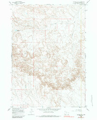
1966 Map of Gilmore Hill
USGS Topo · Published 1984About this map
Gilmore Hill dominates this portion of Park County, providing a high-elevation perspective on the drainage systems and early water infrastructure of the mid-1960s. The landscape is defined by the winding course of Whistle Creek and its major tributaries, including North Branch and West Branch. Water management in this arid environment is evidenced by the Whistle Creek Reservoir and the engineered route of the Wiley Canal near the southern boundary.
Find a feature on this map
13 named features on this map. Tap any name to fly to it.
Don’t see what you’re looking for? This feature index may not catch every label — zoom into the map to look around manually.
Map Details
Editions of this 1966 Gilmore Hill Map
2 editions found

Other maps of this area

1911 · Oregon Basin
USGS Topo · 1:62,500

1913 · Oregon Basin
USGS Topo · 1:62,500

1951 · Y U Bench NW
USGS Topo · 1:24,000

1951 · Y U Bench NE
USGS Topo · 1:24,000

1955 · Cody
USGS Topo · 1:250,000

1958 · Cody
USGS Topo · 1:250,000

1962 · Cody
USGS Topo · 1:250,000

1966 · Gilmore Hill NE
USGS Topo · 1:24,000

1966 · Gilmore Hill SE
USGS Topo · 1:24,000

1966 · Stone Barn Camp
USGS Topo · 1:24,000