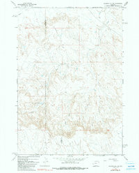
1966 Map of Gilmore Hill SE
USGS Topo · Published 1991About this map
The Park and Big Horn county line bisects this high-country landscape, where the deeply dissected drainage basins of Whistle Creek and Coon Creek dominate the topography. Historically significant as a transcontinental passage, the Jim Bridger Trail winds through the central part of the quadrangle, following the natural contours of the ridges above the West Fork. The water distribution across this arid region is marked by small-scale features like the Well and Johnson Reservoir No 2, indicating the infrastructure necessary for land use in the mid-1960s. The convergence of the South Fork and various tributary drainages creates a complex system of draws and spurs that define the local relief, providing a clear record of the area's geological character before modern development or large-scale landscape modification.
Find a feature on this map
8 named features on this map. Tap any name to fly to it.
Don’t see what you’re looking for? This feature index may not catch every label — zoom into the map to look around manually.
Map Details
Editions of this 1966 Gilmore Hill SE Map
2 editions found
Other maps of this area

1951 · Burlington
USGS Topo · 1:24,000

1951 · Y U Bench NW
USGS Topo · 1:24,000

1951 · Y U Bench NE
USGS Topo · 1:24,000

1955 · Cody
USGS Topo · 1:250,000

1958 · Cody
USGS Topo · 1:250,000

1962 · Cody
USGS Topo · 1:250,000

1966 · Gilmore Hill NE
USGS Topo · 1:24,000

1966 · Gilmore Hill SE
USGS Topo · 1:24,000

1966 · Jack Horner Reservoir
USGS Topo · 1:24,000

1966 · Gilmore Hill NW
USGS Topo · 1:24,000