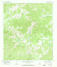
1970 Map of Jack Mountain
USGS Topo · Published 1973About this map
The Cedar Hill Divide splits the high country where Bandera, Bexar, and Medina counties converge, defining a landscape of springs and creek headwaters. In this early 1970s topography, San Geronimo Creek flows southward from the hills, while family-named landmarks like Mount Smith and the Heimsath Cem dot the terrain. The presence of the Clifton Sch and various local springs, including Beekman Spring and Wolf Head Spring, indicates a rural settlement pattern deeply tied to the reliable water sources found in these limestone hills.
Find a feature on this map
32 named features on this map. Tap any name to fly to it.
Don’t see what you’re looking for? This feature index may not catch every label — zoom into the map to look around manually.
Map Details
Editions of this 1970 Jack Mountain Map
2 editions found
Other maps of this area

1953 · Helotes
USGS Topo · 1:24,000

1953 · Van Raub
USGS Topo · 1:24,000

1954 · San Antonio
USGS Topo · 1:250,000

1956 · Comfort
USGS Topo · 1:62,500

1956 · Medina Lake
USGS Topo · 1:62,500

1957 · Boerne
USGS Topo · 1:62,500

1957 · San Antonio
USGS Topo · 1:250,000

1964 · Boerne
USGS Topo · 1:24,000

1964 · Medina Lake
USGS Topo · 1:24,000
1964 · Ranger Creek
USGS Topo · 1:24,000