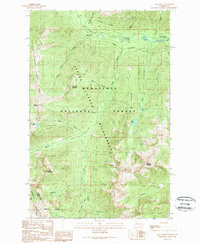
1989 Map of Jack Ridge
USGS Topo · Published 1989About this map
Wenatchee National Forest and the Alpine Lakes Wilderness dominate this high-elevation landscape, where the administrative boundary between Chelan and Kittitas Counties follows the crest of the Wenatchee Mountains. The terrain is characterized by prominent peaks like Bootjack Mountain and Highchair Mountain, separated by a complex network of drainages including Icicle Creek and Jack Creek. Human presence is largely confined to seasonal recreation and historical resource extraction, evidenced by the Black Pine Campground, Rock Island Campground, and Chatter Creek Campground in the north. A series of prospects near Van Epps Creek point to the area's mineral exploration history, while a designated Pack Trail and numerous water features like Trout Lake and Cradle Lake mark the territory for back-country travelers. The map also records physical infrastructure for river crossings, noting a Ford, Rapids, and a Footbridge along the creeks.
Find a feature on this map
37 named features on this map. Tap any name to fly to it.
Don’t see what you’re looking for? This feature index may not catch every label — zoom into the map to look around manually.
Map Details
Editions of this 1989 Jack Ridge Map
This is the sole edition of this map. No revisions or reprints were ever made.
Other maps of this area

1897 · Mount Stuart
USGS Topo · 1:125,000

1901 · Chiwaukum
USGS Topo · 1:125,000

1901 · Snoqualmie Pass
USGS Topo · 1:125,000

1902 · Skykomish
USGS Topo · 1:125,000

1902 · Mount Stuart
USGS Topo · 1:125,000

1903 · Snoqualmie
USGS Topo · 1:125,000

1904 · Chiwaukum
USGS Topo · 1:125,000

1905 · Skykomish
USGS Topo · 1:125,000

1957 · Wenatchee
USGS Topo · 1:250,000

1961 · Mount Stuart
USGS Topo · 1:62,500