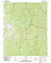
1988 Map of Jacks Gap
USGS Topo · Published 1988About this map
Brasstown Bald dominates the northern skyline of this 1980s landscape, marking the highest point in the region within the Chattahoochee National Forest. The map documents the convergence of the Blue Ridge and various secondary ridges like Wolfpen Ridge and Locust Log Ridge. Settlement is clustered primarily in the west along Town Creek, where the small communities of Fain and Town Creek sit near the junction of several rural roads. Evidence of local history and family legacy is visible at Pine Top Ch and the adjacent Pine Top Cem. The drainage pattern is complex, with the Nottely River flowing through the southern portion of the quadrangle. This survey was field checked just as modern conservation and tourism became central to the area, evidenced by the presence of the Appalachian National Scenic Trail and the Visitors Center atop the peaks.
Find a feature on this map
115 named features on this map. Tap any name to fly to it.
Don’t see what you’re looking for? This feature index may not catch every label — zoom into the map to look around manually.
Map Details
Editions of this 1988 Jacks Gap Map
This is the sole edition of this map. No revisions or reprints were ever made.
Other maps of this area

1886 · Dahlonega
USGS Topo · 1:125,000

1892 · Dahlonega
USGS Topo · 1:125,000

1896 · Dahlonega
USGS Topo · 1:125,000

1903 · Dahlonega
USGS Topo · 1:125,000

1935 · Coosa Bald
USGS Topo · 1:24,000

1935 · Osborn
USGS Topo · 1:24,000

1935 · Cowrock
USGS Topo · 1:24,000

1935 · Tray Mountain
USGS Topo · 1:24,000
1935 · Gumlog
USGS Topo · 1:24,000

1935 · Jacks Gap
USGS Topo · 1:24,000