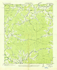
1935 Map of Gumlog
USGS Topo · Published 1935About this map
Blairsville anchors the southern portion of this landscape, situated near the banks of the Nottely River and Butternut Creek. This 1935 study reveals a rural community structured around its watercourses and gaps, with a high density of small schools and churches serving remote mountain valleys. Features like Ownby Mill and Smarney Sch indicate localized industrial and educational centers that once defined daily life in the Blue Ridge foothills.
Find a feature on this map
68 named features on this map. Tap any name to fly to it.
Don’t see what you’re looking for? This feature index may not catch every label — zoom into the map to look around manually.
Map Details
Editions of this 1935 Gumlog Map
This is the sole edition of this map. No revisions or reprints were ever made.
Other maps of this area

1886 · Dahlonega
USGS Topo · 1:125,000

1888 · Ellijay
USGS Topo · 1:125,000

1892 · Dahlonega
USGS Topo · 1:125,000

1892 · Ellijay
USGS Topo · 1:125,000

1893 · Murphy
USGS Topo · 1:125,000

1896 · Dahlonega
USGS Topo · 1:125,000

1898 · Ellijay
USGS Topo · 1:125,000

1903 · Dahlonega
USGS Topo · 1:125,000

1911 · Ellijay
USGS Topo · 1:125,000

1914 · Murphy
USGS Topo · 1:125,000