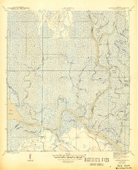
1945 Map of Jackson River
USGS Topo · Published 1945About this map
The Apalachicola River dominates this mid-1940s landscape, winding through a labyrinth of sloughs, bayous, and secondary channels along the boundary of Gulf and Franklin counties. This riverine system is defined by complex hydrological features like St Marks Island, which is partitioned by the St. Marks River and the Northern River. The map reveals a wild, wetland environment where major water bodies like Lake Wimico connect to the gulf via the Jackson River.
Find a feature on this map
39 named features on this map. Tap any name to fly to it.
Don’t see what you’re looking for? This feature index may not catch every label — zoom into the map to look around manually.
Map Details
Editions of this 1945 Jackson River Map
4 editions found

Other maps of this area

1943 · West Pass
USGS Topo · 1:31,680

1943 · Apalachicola
USGS Topo · 1:31,680

1943 · Indian Pass
USGS Topo · 1:24,000

1943 · Jackson River
USGS Topo · 1:24,000

1944 · White City
USGS Topo · 1:24,000

1944 · Apalachicola
USGS Topo · 1:24,000

1944 · Forbes Island
USGS Topo · 1:24,000

1945 · Forbes Island
USGS Topo · 1:31,680

1945 · Lake Wimico
USGS Topo · 1:31,680

1945 · White City
USGS Topo · 1:31,680