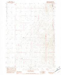
1982 Map of Jackson Well
USGS Topo · Published 1982About this map
Jackson Well serves as a vital water point in this arid stretch of the Nevada desert, where the reliance on isolated springs and wells dictates the human footprint. The landscape is defined by the sharp contrast between the level expanse of the Alkali Flat and the rising elevations of the Slumbering Hills to the east. These hills contain the Jumbo Mine, representing the region's enduring connection to mineral exploration and resource extraction. Compiled from 1970s aerial photography and field checks, the map captures a period of high-desert land management where named landmarks like Austin Well and Franklin Well were essential coordinates for surveyors and ranchers alike. The gridded section lines of Township 40 North and Range 35 East overlay a terrain where water sources are the primary indicators of historical activity.
Find a feature on this map
8 named features on this map. Tap any name to fly to it.
Don’t see what you’re looking for? This feature index may not catch every label — zoom into the map to look around manually.
Map Details
Editions of this 1982 Jackson Well Map
This is the sole edition of this map. No revisions or reprints were ever made.
Other maps of this area

1882 · Paradise
USGS Topo · 1:250,000

1886 · Disaster
USGS Topo · 1:250,000

1893 · Paradise
USGS Topo · 1:250,000

1893 · Disaster
USGS Topo · 1:250,000

1954 · Vya
USGS Topo · 1:250,000

1955 · McDermitt
USGS Topo · 1:250,000

1958 · Vya
USGS Topo · 1:250,000

1958 · Awakening Peak
USGS Topo · 1:62,500

1959 · McDermitt
USGS Topo · 1:250,000

1962 · Vya
USGS Topo · 1:250,000