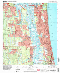
1994 Map of Jacksonville Beach
USGS Topo · Published 2003About this map
Pablo Creek and the Intracoastal Waterway carve through the coastal wetlands of Duval County, separating the barrier island communities from the mainland. This mid-1990s landscape showcases the intense development of Jacksonville Beach, Neptune Beach, and Atlantic Beach along the Atlantic Ocean. To the north, the Mayport Naval Station occupies a strategic position, while the Timucuan National Ecological and Historic Preserve protects the brackish marshes around Spanish Point and Four Pines Island. Genealogical details are preserved in sites like the Rain Cem and Warren Smith Cem, alongside local institutions like Fletcher High Sch. The map reveals the intricate water network of Greenfield Creek and Hopkins Creek, which defined the early footprint of settlements like San Pablo and Donner before modern expansion.
Find a feature on this map
84 named features on this map. Tap any name to fly to it.
Don’t see what you’re looking for? This feature index may not catch every label — zoom into the map to look around manually.
Map Details
Editions of this 1994 Jacksonville Beach Map
This is the sole edition of this map. No revisions or reprints were ever made.
Other maps of this area

1917 · Orange Park
USGS Topo · 1:62,500

1918 · Jacksonville
USGS Topo · 1:62,500

1918 · Orange Park
USGS Topo · 1:62,500

1918 · Palm Valley
USGS Topo · 1:62,500

1918 · Mayport
USGS Topo · 1:62,500

1948 · Jacksonville
USGS Topo · 1:250,000

1948 · Jacksonville Beach
USGS Topo · 1:24,000

1948 · Eastport
USGS Topo · 1:24,000

1949 · Jacksonville Beach
USGS Topo · 1:24,000

1950 · Arlington
USGS Topo · 1:24,000