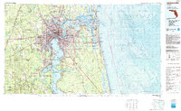
1977 Map of Jacksonville
USGS Topo · Published 1983About this map
The St Johns River and its intricate estuaries define the landscape of Northeast Florida during this late-1970s period of growth. As Jacksonville expanded, the region maintained a massive military presence, anchored by Mayport Naval Station on the coast and Jacksonville Naval Air Station further inland. The map details the complex shoreline where the Intracoastal Waterway threads behind barrier islands like Talbot Island and Little Talbot Island, revealing a coastline still shaped by tidal currents and the Nassau Sound.
Find a feature on this map
161 named features on this map. Tap any name to fly to it.
Don’t see what you’re looking for? This feature index may not catch every label — zoom into the map to look around manually.
Map Details
Editions of this 1977 Jacksonville Map
This is the sole edition of this map. No revisions or reprints were ever made.
Other maps of this area

1917 · Orange Park
USGS Topo · 1:62,500

1917 · Cambon
USGS Topo · 1:62,500

1917 · Macclenny
USGS Topo · 1:62,500

1917 · Hilliard
USGS Topo · 1:62,500

1918 · St Marys
USGS Topo · 1:62,500

1918 · Middleburg
USGS Topo · 1:62,500

1918 · Moniac
USGS Topo · 1:62,500

1918 · Lawtey
USGS Topo · 1:62,500

1918 · Cambon
USGS Topo · 1:62,500

1918 · Jacksonville
USGS Topo · 1:62,500