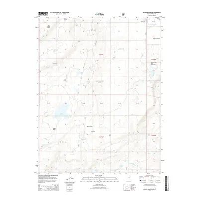
2014 Map of Jacobs Reservoir
USGS Topo · Published 2014About this map
Dixie National Forest encompasses this high-elevation landscape on the Aquarius Plateau, where a complex network of small lakes and alpine meadows defines the geography. The map illustrates a high-country hydrologic system anchored by the Jacobs Reservoir and numerous smaller bodies of water such as Bakeskillet Lake, Purple Lake, and the clustered Row Lakes. This area of Garfield County is characterized by significant topographic features including the Stairs Slope and the distinctive depression of Jacobs Valley. The presence of features like Boulder Swale and Basin Flats indicates the glacial and volcanic history of the plateau. For those tracing the local landscape, the map reveals specific landmarks like Burr Top and South Point, providing a detailed look at the drainage patterns of Bear Cr and Sand Cr before they descend from the plateau rim.
Find a feature on this map
50 named features on this map. Tap any name to fly to it.
Don’t see what you’re looking for? This feature index may not catch every label — zoom into the map to look around manually.
Map Details
Editions of this 2014 Jacobs Reservoir Map
This is the sole edition of this map. No revisions or reprints were ever made.
Other maps of this area

1885 · Fish Lake
USGS Topo · 1:250,000

1886 · Escalante
USGS Topo · 1:250,000

1896 · Fish Lake
USGS Topo · 1:250,000

1952 · Notom 3 SW
USGS Topo · 1:24,000

1952 · Notom 3 NW
USGS Topo · 1:24,000

1952 · Grover
USGS Topo · 1:62,500

1953 · Loa 4 NE
USGS Topo · 1:24,000

1956 · Escalante
USGS Topo · 1:250,000

1956 · Salina
USGS Topo · 1:250,000

1960 · Escalante
USGS Topo · 1:250,000